
The field of Geographic Information Systems (GIS) has been developed over the last five decades. On the most basic level, GIS is a spatial system that creates, manages, analyzes, and maps all types of data. Among the functionalities of GIS, we can also find data storage. GIS connects data to a map, integrating location data (where things are) with all types of descriptive information (what things are like there). This provides a foundation for mapping and analysis that is used in science and almost every industry.
How is GIS used?
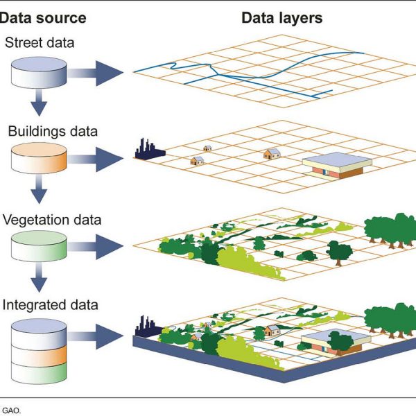
Many different types of information can be compared and contrasted using GIS. The system can include data about people, such as population, income, or education level. It can include information about the landscape, such as the location of streams, different kinds of vegetation, and different kinds of soil. It can include information about the sites of factories, farms, and schools, or storm drains, roads, and electric power lines. GIS helps users understand patterns, relationships, and geographic context.
Discover the power of geography in this series of video shorts by National Geographic and Esri, featuring National Geographic Explorers who are using GIS to map a better future:
SETIN works with GIS technology in several projects, one of them is the “Assistance service, specialist support for updating cartographic database and development of GIS models to support the engineering operational units” for TERNA Rete Italia S.p.a., Italian Owner of National Electric Power lines network that deals with the operation, maintenance and development of the electric national transmission grid.
The four years’ Framework Contract (March 2023 – present) includes the specialist support for the development of GIS and Web-GIS applications and Models using Python for the calculation of environmental parameters; updating of the national criteria for the Strategic Environmental Assessment procedure; Environmental evaluations through cartography analysis for infrastructures development projects; further specialized IT / cartographic support activities.